-
-

Welcome to ForestVision!
-

Over 15 billion trees are gone globally due to deforestation
-

The majority of deforestation is in Africa and South America
-

The carbon emission certificate market is generally intransparent
-

Our Tech Stack for building ForestVision
-

Using ForestVision impacts organizations and Planet Earth positively
-

We are ForestVision
-

Please vote us to pitch our presentation to everyone. Thank you very much!
-

Now it's up to you to decide!


Inspiration
15.3 billion trees are lost annually to deforestation worldwide. If stacked, these trees would reach the moon and back almost 6 times.
Situation for the majority of forests (in many developing countries) will worsen drastically in the next decade if we don't mitigate deforestation behaviour.
Our goal is to leverage machine learning to detect deforestation as fast as possible, helping NGOs to verify real world forest changes before reporting the situation to the osapiens platform.
The inspiration came from the growing levels of anxiety of German Dax and SME companies surounding the supply chain regulations in Germany. This massive regulatory framework will affect all enterprises within the European Union that have to prove their ESG standards or they face huge financial penalties. Another problem is that most ESG platforms don't have a thorough vetting process for reforestation projects. There needs to be an easy way to empower NGOs to help companies and governments to verify that reforestation projects are being executed and deforestation being prevented effectively.
What it does
Our project, ForestVision, utilizes advanced machine learning techniques to detect signs of deforestation in satellite images, enabling timely intervention and action. By integrating TensorFlow for image processing and analysis, our AI model identifies areas where forests are being diminished, distinguishing these from other land uses such as agricultural or urban areas.
The system processes satellite data to highlight ongoing deforestation activities, sending alerts to NGOs and relevant stakeholders. This rapid reporting mechanism is crucial for the implementation of effective reforestation projects and for ensuring compliance with environmental standards and regulations.
In addition to deforestation detection, our application provides an intuitive platform for NGOs to monitor forested areas over time. This enables them to observe changes and trends, contributing to long-term environmental planning and sustainability efforts. By making these tools accessible and easy to use, we empower NGOs to support companies and governments in maintaining their ESG standards, thereby avoiding potential financial penalties under the new EU regulations.
Through ForestVision, we aim to provide a reliable and efficient solution to combat deforestation globally, offering a proactive approach to environmental conservation and compliance with global sustainability standards.
How we built it
TL;DR:
- ML model: Our ML model uses TensorFlow as it's AI library and the Python programming language.
- App: The user interface is a cross-platform application built with the Flutter framework, Google Maps, Dart programming language and EuroSat dataset.
- Pitch Deck: Our presentation was made with Microsoft PowerPoint. We used Consensus AI and Perplexity.ai for scientific research.
How we built the ForestVision AI model
Our Ai is more than a proof of concept, it actually can detect forests through satellite images. This is achived via 2 steps:
- labeling
- training
Most of the pre-processing was already done by publicly available data (e.g. EuroSAT). These data is crutial for training the AI model.
 Credits: Stanford University
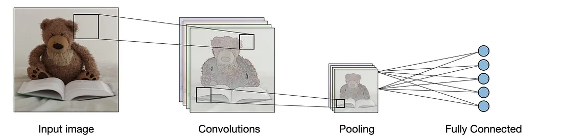
Our AI model is a Convolutional Neural Network (CNN), which is able to detect certain patterns. Convolutional layers are the core of all image detection AIs. These patterns can be detected in images because they exist. Forests have a different color, form or density then i.e. highways. These differences are detected by our Tensorflow AI model.
This is our AI model architecture:
model_with_all = models.Sequential([
    layers.Conv2D(16, (3, 3), activation='relu', input_shape=(64, 64, 3), padding='same'),
    layers.MaxPooling2D((2, 2)),

    layers.Conv2D(32, (3, 3), activation='relu', input_shape=(64, 64, 3), padding='same'),
    layers.MaxPooling2D((2, 2)),

    layers.Conv2D(64, (3, 3), activation='relu', input_shape=(64, 64, 3), padding='same'),
    layers.MaxPooling2D((2, 2)),

    layers.Flatten(),
    layers.Dense(128, activation='relu'),
    layers.Dense(10, activation='softmax')
])
How we built the ForestVision Application
We used the Flutter framework to code our user interface and application. We integrated Google Earth (with Google Maps) into our program.
The whole demo has been automatically deployed to Amazon Web Services (AWS) thanks to GitHub CD hooks.
It can be reached under master.d1km9kglkh3cke.amplifyapp.com.
Challenges we ran into
- Day 1: Struggled to build a basic AI model as ML beginners.
- Day 2: Summarize our pitch to max. 5 min.
Accomplishments that we're proud of
- We hope that we helped osapiens with our solution to empower NGOs, companies and organization to to make better decisions
- We successfully created an AI model in Tensorflow
What we learned
- AI/ML can be really beneficial and impactful if you find the right use case
- Learned new things about AI/ML (such as CNN) as total beginners
- Learned to use Flutter as Framework better
- Learned to build a business case from scratch
What's next for ForestVision
We want to built our Minimum Viable Product (MVP) by enhancing frontend and backend connection and increasing our AI model accuracy.
Regarding business model, we currently make money with deforestation but want to extend our product portfolio to afforestation projects.
Maybe starting a start-up with this MVP? But definitely interested in joining the osapiens workforce.
Last but not least...
Thanks to everyone making this event possible! Not only the organizers but definitely you, too!
DEAR JUDGES, WE LOVE TO GET THE OPPORTUNITY TO PITCH IN THE FINALS TO EVERYONE. THANK YOU FOR CONSIDERING THIS!
All the best!
Your ForestVision team
Built With
- amazon-web-services
- c
- c++
- consensus
- css3
- dart
- flutter
- global-forest-watch-api
- google-earth-engine
- google-maps
- html5
- javascript
- perplexity-ai
- tensorflow


Log in or sign up for Devpost to join the conversation.